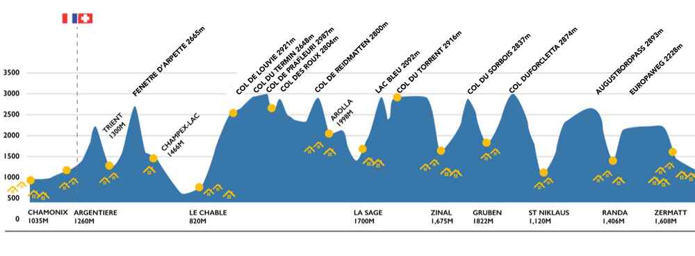
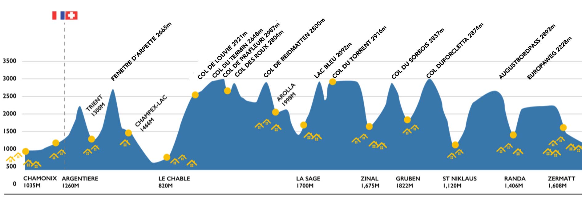
If you look at a map of the region, it looks unclear how you would possibly get from Chamonix to Zermatt easily. The Walker’s Haute Route works its way through a complex mass of mountains passable only via high mountain cols and connecting valleys. Traditionally, the trek starts in the Chamonix Valley and moves south eastwards via Argentiere and then over the French-Swiss border to Trient, and follows the same route as the Tour du Mont Blanc as far as Champex-Lac.
Here, the route splits and the Haute Route heads away from the Mont Blanc massif towards Chable and once up and above Verbier, the route stays high for two days passing numerous cols before descending to Arolla. From thereon, the route moves from valley to col to valley on a daily basis, passing through the Valasian villages of Les Hauderes, Zinal and Gruben before finally arriving in the Matterhorn Valley.
There are a number of variants passing over different cols on some days, including the adaptation of the Europaweg (a high level route into Zermatt) rather than staying in the valley bottom. The Walker’s Haute Route is often undertaken in reverse and can seem very different when done in the opposite direction.
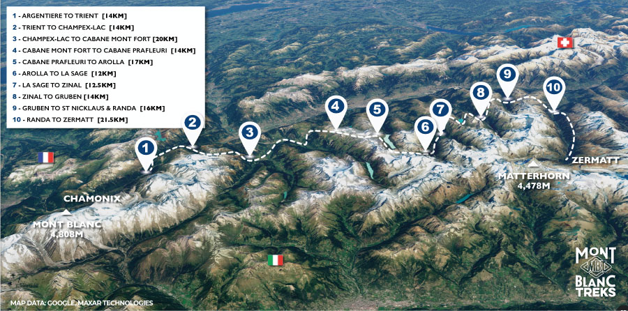
Journeying over a distance of 180km the Walkers Haute Route is fast becoming a 'must do' long distance trek. This trek is rigorous to say the least and is reserved for the fittest of mountain walkers as the daily height gain on the Walkers Haute Route full self guided trek can be substantial with the overall accumulation of 12,000m. The Haute Route self guided trek takes you over 11 mountain cols and through 2 alpine regions within France and Switzerland from Chamonix to Zermatt. Not for the faint hearted and when undertaken self-guided, a good deal of mountain experience is advisable.
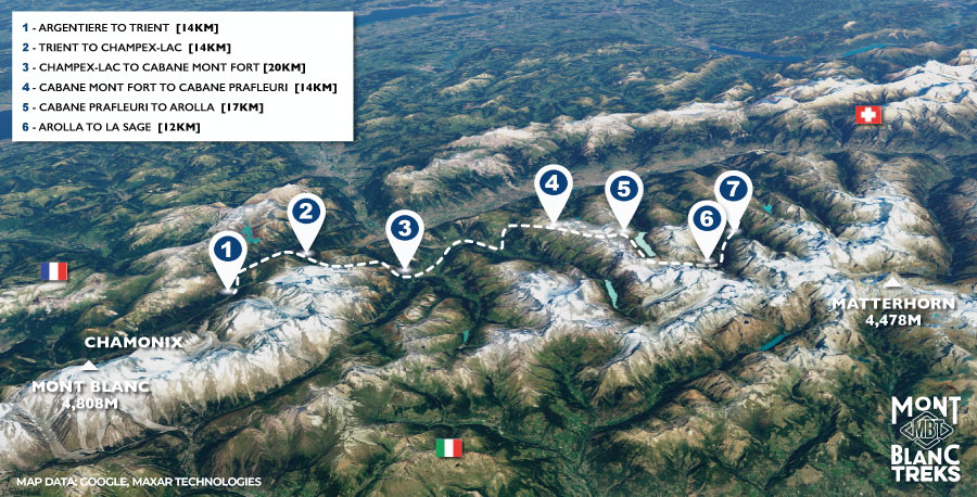
This Walkers Haute Route westerly trek takes you from the famous alpine town of Chamonix in the French alps to the beautiful Valaisian village of Les Hauderes and La Sage in the Evolene valley. This westerly section takes you over 115km of stunning high mountain terrain and through idyllic alpine pastures. This trek is ideal for those who haven't the time to complete the full route yet want a real flavour of this classic trek.
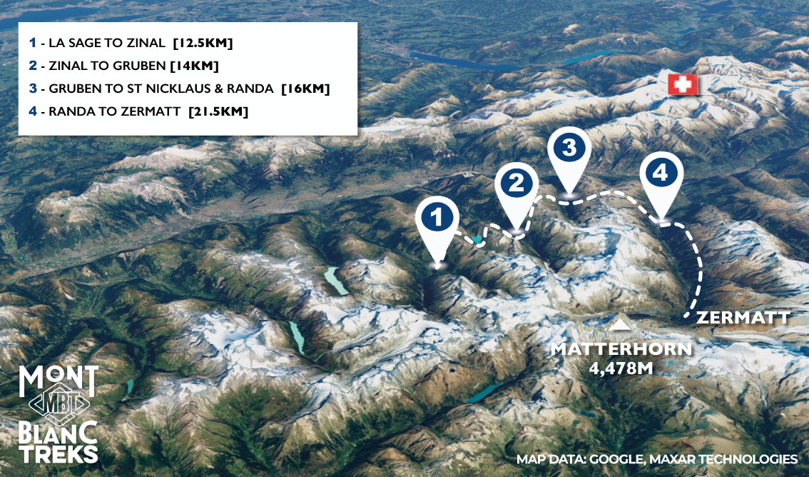
Trek from La Sage in the beautiful Evolene valley to the famous town of Zermatt on this 80km easterly section of the classic Walkers Haute Route. The Walkers Haute Route easterly sef guided trek takes you over high mountain cols and descends into the traditional Valasian valleys of Zinal, Gruben and the Matterhorn. This trek is ideal for those wanting to trek independently & experience the route in a shorter space of time.
Journeying over a distance of 180km the Walkers Haute Route is a 'must do' long distance trek. This trek is rigorous to say the least and is reserved for the fittest of mountain walkers as the daily height gain on the full Walkers Haute Route can be substantial with the overall accumulation of 12,000m. The Walkers Haute Route takes you over 11 mountain cols and through 2 alpine regions within France and Switzerland from Chamonix to Zermatt. Not for the faint hearted and when undertaken self-guided, a good deal of mountain experience is advisable.
We take a short bus ride to Montroc where we start the route with an ascent to the Col du Balme via the beautiful Aiguillette des Possettes. We make our way to the col by crossing the border into Switzerland and descending to the Swiss village of Trient.
Leaving Trient, we climb steeply to the Fenetre d’Arpette. A tricky descent over boulders leads us to pastureland and to the picture postcard village of Champex-Lac.
We start the day with an easy descent into to the Orsiére Valley and trough the Swiss villages of Sembrancher and Châble. From Châble, we take the cable car to Les Ruinettes within the Verbier ski area and a short trek will take us to the Cabane du Mont Fort.
We make our way on a lofty traverse via the Sentier des Chamois to the Col du Termin. From here, we continue to the rocky Col de Louvie and traverse below the Grand Desert Glacier where we pass a series of small tarns before ascending once more to the Col de Prafleuri and descending steeply to the Cabane de Prafleuri.
Passing over the Col des Roux, we descend to the Lac Dix and contour above the shoreline for several kilometers before rising again to the Col de Riedmatten. Descending from the col, we finally reach the small Alpine village of Arolla.
An easy day as we make our way via Lac Bleu to the typical Valaisian village of Les Hauderes and on to the hamlet of La Sage in the Val d'Herens. We arrive in Val d'Herens around mid-afternoon with time to rest and relax.
We climb steadily to the Col du Torrent before descending via Lac Autannes to Lac de Moiry and the barrage. From here, we have two options. Ascend towards Col de Sorebois and descend steeply through the ski area where you take the cable car to Zinal, or take the bus from the barrage to Zinal to shorten the route and reduce the height gain and descent (dependent on weather, fatigue and time).
A steady climb through woodland to the high mountain pastureland passing the remote Barnueza Alpage. Once at the Col du Forcletta, we make your descend in to the Gruben valley to the small village of Gruben.
Another steep climb from Gruben to high-level pastures of the Augustbordpass. We make your descent steadily from the col towards Jungen where we take the little cable car to St Niklaus and a short train ride on the Matterhorn express to Randa.
Departing from Randa, we ascend to the Europaweg and take the impressive Charles Kuonen suspension bridge for the final day on this stunning traverse via Taschalp and finish taking the hight route into Zermatt.
1. Argentière to Trient
2. Trient to Champex Lac
3. Champex Lac to Cabane Mont Fort
4. Cabane Mont Fort to Cabane Prafleuri
5. Cabane Prafleuri to Arolla
6. Arolla to La Sage
7. La Sage to Zinal
8. Zinal to Gruben
9. Gruben to St Niklaus
10. St Niklaus to Zermatt
Walkers Haute Route Map - Westerly Route
This Walkers Haute Route westerly trek takes you from the famous alpine town of Chamonix in the French alps to the beautiful Valaisian village of Les Hauderes and La Sage in the Evolene valley. This westerly section takes you over 115km of stunning high mountain terrain and through idyllic alpine pastures. This trek is ideal for those who haven't the time to complete the full route yet want a real flavour of this classic trek.
We take a short bus ride to Montroc where we start the route with an ascent to the Col du Balme via the beautiful Aiguillette des Possettes. We make our way to the col by crossing the border into Switzerland and descending to the Swiss village of Trient.
Leaving Trient, we climb steeply to the Fenetre d’Arpette. A tricky descent over boulders leads us to pastureland and to the picture postcard village of Champex-Lac.
We start the day with an easy descent into to the Orsiére Valley and trough the Swiss villages of Sembrancher and Châble. From Châble, we take the cable car to Les Ruinettes within the Verbier ski area and a short trek will take us to the Cabane du Mont Fort.
We make our way on a lofty traverse via the Sentier des Chamois to the Col du Termin. From here, we continue to the rocky Col de Louvie and traverse below the Grand Desert Glacier where we pass a series of small tarns before ascending once more to the Col de Prafleuri and descending steeply to the Cabane de Prafleuri.
Passing over the Col des Roux, we descend to the Lac Dix and contour above the shoreline for several kilometers before rising again to the Col de Riedmatten. Descending from the col, we finally reach the small Alpine village of Arolla.
An easy day as we make our way via Lac Bleu to the typical Valaisian village of Les Hauderes and on to the hamlet of La Sage in the Val d'Herens. We arrive in Val d'Herens around mid-afternoon with time to rest and relax.
1. Argentière to Trient
2. Trient to Champex Lac
3. Champex Lac to Cabane Mont Fort
4. Cabane Mont Fort to Cabane Prafleuri
Walkers Haute Route Map - Easterly Route
Trek from La Sage in the beautiful Evolene valley to the famous town of Zermatt on this 80km easterly section of the classic Walkers Haute Route. The Walkers Haute Route easterly sef guided trek takes you over high mountain cols and descends into the traditional Valasian valleys of Zinal, Gruben and the Matterhorn. This trek is ideal for those wanting to trek independently & experience the route in a shorter space of time.
We climb steadily to the Col du Torrent before descending via Lac Autannes to Lac de Moiry and the barrage. From here, we have two options. Ascend towards Col de Sorebois and descend steeply through the ski area where you take the cable car to Zinal, or take the bus from the barrage to Zinal to shorten the route and reduce the height gain and descent (dependent on weather, fatigue and time).
A steady climb through woodland to the high mountain pastureland passing the remote Barnueza Alpage. Once at the Col du Forcletta, we make your descend in to the Gruben valley to the small village of Gruben.
Another steep climb from Gruben to high-level pastures of the Augustbordpass. We make your descent steadily from the col towards Jungen where we take the little cable car to St Niklaus and a short train ride on the Matterhorn express to Randa.
Departing from Randa, we ascend to the Europaweg and take the impressive Charles Kuonen suspension bridge for the final day on this stunning traverse via Taschalp and finish taking the hight route into Zermatt.